Why Rivers Draw Curves Across Flat Ground
Why rivers draw curves across flat ground becomes clear in the water’s shifting bends, abandoned channels, and floodplain patterns that preserve a river’s earlier course.
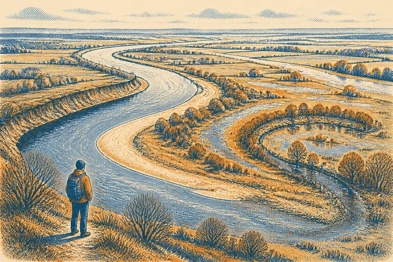
The common mistake is to read a river’s present channel as a fixed line, as if it had been laid across the plain and left there. Why rivers draw curves across flat ground is easier to see when you treat the channel as a moving edge: water wears at some banks, leaves sediment at others, and can shift the whole course over time. On a broad floodplain, those changes often leave a record beside the river that is visible long after the water has moved on.
1. A bend begins with uneven flow
A river does not move at the same speed from bank to bank. In a bend, the current tends to press harder against the outer bank, where it can loosen soil and carry material downstream. Along the inner bank, slower water allows some of that sediment to settle. The two sides change at different rates, and the bend becomes more pronounced.
Small differences can help start this pattern: a patch of resistant ground, a tree fallen into the channel, a shallow bar of sand, or a slight change in the riverbed. Once the flow curves around such a feature, the moving water reinforces the curve. A bend is therefore not simply a decorative shape imposed on a plain; it is a record of water responding to material and then changing that material in return.
2. The current shifts within the curve
Water in a bend follows a more complicated path than the channel’s outline suggests. The faster current is often directed toward the outside of the curve, while slower water near the bed and banks can carry sediment in different directions. This circulation helps explain why erosion and deposition happen side by side rather than evenly across the channel.
Look from a safe, dry bank for a steep, freshly exposed face on the outside of a bend and a gentler, gravelly or sandy margin on the inside. Those contrasting surfaces are clues to how the river is changing. Their appearance varies with the river’s material and water level, so a single visit offers a snapshot, not a full account of its movement.
3. Floods can move the channel’s boundary
During ordinary flow, a river may work gradually at its banks. When water rises and spreads over the floodplain, the river can reach beyond its usual channel, carry sediment across low ground, and exploit a shorter route between parts of a bend. A flood may enlarge an existing channel, cut a new passage, or leave water and sediment in places that were dry during calmer conditions.
Floodplains are not empty margins beside a river. They are places the river has repeatedly occupied, though not always in the same way or along the same line. Deposits of fine mud, sand, and gravel can vary across the plain because water loses speed as it spreads. The resulting ground can hold small differences in height and texture that help reveal where water once traveled.
4. Old channels remain legible after water leaves
A river that abandons a bend may leave a crescent-shaped depression, a damp strip, a line of ponds, or a subtle change in vegetation. The abandoned curve may become isolated when the river cuts across the narrow neck of a meander and the former loop is left apart from the main channel. Over time, sediment and plant growth can partly fill it, but its shape may still be visible in the land.
Not every curved mark is an old river channel. Drainage ditches, field edges, roads, and later engineering can also produce arcs or lines. A stronger reading comes from several clues together: a curved hollow that follows the shape of a river bend, differences in soil or vegetation, and nearby low ground that connects the trace to the floodplain.
5. A floodplain keeps more than one version of the river
From a viewpoint, a river can seem to occupy a single channel. Across the wider plain, though, older bends and smaller channels may preserve the outlines of former courses. Some are obvious as water-filled oxbows; others appear only as shallow swales, damp fields, or a line of willow and alder where the soil stays moist.
These traces give the floodplain depth in time. The present channel is one part of a larger pattern, and the ground beside it can show where the river once spread or turned. A useful reading distinguishes the active channel—the waterway carrying the river now—from paleochannels, older routes left behind by earlier movement. The word “old” does not tell you precisely when a channel was active, but the contrast helps describe what the land is showing.
6. Human changes can obscure or redirect the evidence
People often straighten, embank, dredge, or confine rivers to protect fields, settlements, roads, and bridges. A straightened stretch can hide the bends that would otherwise develop there, while a raised bank may limit ordinary flooding in one area and redirect water elsewhere. Drainage works can also create narrow, regular channels that resemble natural traces at a glance.
That does not make the landscape unreadable; it means the evidence has more than one layer. A straight channel beside a looping hollow may reflect a river that was altered after it formed its earlier course. An embankment, bridge, or managed outfall can help explain the present arrangement, while nearby low ground may retain signs of older water movement. It is not worth the effort to assign an exact age to every curved depression during an ordinary walk; the more useful question is what features support the reading that water shaped it.
7. A careful walk connects the clues
Imagine you are standing on a public path beside a straightened river, with a crescent-shaped wet hollow beyond the bank. You notice that the hollow curves roughly alongside the present channel and that a line of moisture-loving shrubs follows its edge. Rather than calling it an abandoned meander on sight, you compare its shape with the river’s bends upstream and look for whether the low ground continues into the floodplain. If those features fit together, an earlier channel becomes a reasonable interpretation, though not a precise date or a complete history.
Keep to public access and firm ground, especially where banks are steep or the floodplain is wet. A paper map or a basic topographic map can help you see how a hollow relates to the present channel; aerial imagery may reveal curves that are difficult to notice from the path. The value lies in comparing what the map suggests with what the ground actually shows, not in treating either view as conclusive by itself.
Questions about river bends and old channels?
Why do rivers meander instead of running straight?
Uneven flow erodes the outside of bends and deposits sediment along the inside, gradually strengthening curves. Differences in the riverbed, banks, and obstacles help the pattern develop.
What is an oxbow lake?
An oxbow lake is a water-filled former bend that has been cut off from the main river. Some abandoned bends gradually become marshy hollows or dry depressions instead of remaining lakes.
How can I tell whether a curved hollow was once a river channel?
Look for a coherent curve, low ground, changes in soil moisture or vegetation, and a relationship to the nearby floodplain. A single clue is not enough to distinguish a former channel from a ditch or other human-made feature.
Do rivers move their bends at the same pace everywhere?
No. The rate and direction of change depend on factors such as the river’s flow, the material in its banks, and human alteration. Some bends shift visibly over time, while others change slowly or are held in place.
Read the curve as a trace, not a promise
Why rivers draw curves across flat ground becomes plain when you follow the exchange between moving water and the floodplain: a bank gives way, sediment settles, a bend grows, and later water may leave the route behind. The present channel tells only part of that story. On the next walk, notice where the ground dips, where damp vegetation follows a curve, and where the river’s current meets a contrasting bank; those ordinary details can make an apparently flat landscape feel newly legible.