The Straight-Line Myth of Old Boundaries
Old boundaries do not always follow streams or ridges. Learn to read their angles, gaps, and surviving marks as traces of practical divisions.
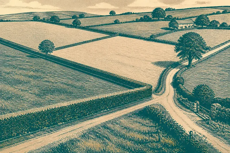
The common mistake when reading an old boundary is to assume it must follow a stream, ridge, or other natural line. That assumption can make a plainly angular hedge or parish edge seem like a failed version of the landscape, when it may instead record a practical division that once mattered to the people who laid it out.
Old boundaries often show their history in small inconsistencies: a hedge that changes direction, a bank that stops short, or a path that skirts a corner rather than crossing it. These are not proof of a particular origin. They are invitations to look closely at how land was divided, used, and maintained.
Old boundaries can preserve decisions rather than landforms
A natural feature offers a convenient line, but it is not the only one available. People have marked holdings, fields, estates, and local jurisdictions with boundaries that fit ownership or work, even when the ground offered no neat guide. A straight stretch may cross a slope; an irregular one may bend around a plot or meet another boundary at an awkward angle.
Look at the boundary’s relationship to its surroundings before trying to name its purpose. Does it meet a lane, a field corner, a building site, or another hedge? Do several boundaries share a direction, or does one cut across the grain of nearby fields? The pattern can suggest that the line belongs to a larger arrangement, though it cannot identify that arrangement on its own.
A hedge, ditch, low bank, wall, or line of trees may all mark a division. Their present appearance can be misleading: a boundary may have been moved, neglected, replanted, or partly erased. Treat what you see as a surviving trace, not a complete record of the original line.
Angles and small jogs deserve a closer look
At a junction, notice whether one boundary continues while another turns into it, or whether both appear to stop and resume beyond the meeting point. A short jog can be easy to miss from a road, but it may show that two lines were laid out separately rather than as parts of one smooth enclosure.
In a field, a low bank may meet a hedge at a right-angled corner even though the nearby slope runs diagonally. Elsewhere, a boundary may make a shallow bend to avoid a wet patch or an existing track. Neither shape tells you why it was made. The useful observation is that the line responds to a human arrangement as well as to the ground.
Take care with apparent straightness, too. A long hedge can look ruler-straight from a distance while making several subtle changes close up. Compare it from more than one safe public viewpoint, and note where the line meets visible landmarks. A route along a boundary may be private, so stay on public paths and roads rather than crossing fields to inspect it.
Read the boundary beside the things it meets
Boundaries become more legible at their ends and intersections. A hedge that runs into a road, a wall that turns around a building, or a ditch that stops at another boundary may reveal more than a long middle stretch. Look for changes in material as well as shape: stone giving way to hedge, a bank becoming a ditch, or trees appearing only along one section.
Also notice the fields on either side. A boundary separating two broad, differently shaped parcels may function differently from one dividing narrow strips. The visible arrangement can suggest distinct uses or phases of division, but avoid treating a pattern as a date or a formal property line without evidence.
Maps can help you compare alignments, but map conventions and detail vary. A line on a map may simplify a hedge, omit a small bank, or show a boundary that is no longer visible. Use the map to ask better questions on the ground, not to overrule what the place actually shows.
What can an irregular boundary tell you?
Does a straight boundary mean it is recent?
No. A straight line can be old, and a crooked one can be new or altered. Shape alone does not establish age; it only gives you something to compare with the land, neighboring divisions, and any reliable local records.
Why might a boundary ignore a stream or ridge?
It may have been drawn to divide holdings, fields, or areas of responsibility rather than to follow a natural feature. The line could also have shifted, or the stream itself may have changed course since the boundary was formed.
What should I record while looking?
Write down the boundary’s material, direction, visible turns, endpoints, and nearby features. A simple sketch with landmarks can preserve the relationship between lines better than a vague note that a hedge “looks old.”
Can a hedge or bank identify a property line?
Not reliably by appearance alone. A visible feature may mark a historic division, a field edge, or a later alteration, and those meanings are not interchangeable. For a current property question, consult the relevant records or a qualified professional.
A short field note is better than a quick explanation
Say you notice a hedge crossing a gentle slope, then turning sharply beside a lane before continuing in another direction. Note the slope, the turn, the lane, and where the hedge resumes. That description leaves room for several explanations; writing “old estate boundary” would claim more than the evidence supports.
For a useful record, include the date of your visit, the public place from which you observed the feature, and what is visible on each side. Add a sketch of junctions and gaps. If you return later, you can compare what has changed without relying on memory.
- Mark the boundary’s visible start and end.
- Describe its material and any change in material.
- Note corners, bends, gaps, and junctions.
- Record nearby lanes, buildings, slopes, and watercourses.
- Separate what you saw from what you think it may mean.
What is not worth the effort is trying to assign every hedge a precise age or owner from its shape alone. A careful description is more useful than a confident label, especially where old divisions have been altered or absorbed into later field patterns.
The straight-line myth makes boundaries seem legible only when they imitate nature. In practice, an angular trace can be just as revealing: it draws attention to an edge that served a purpose beyond the shape of the land. The next time a hedge makes an unexpected turn, note what it meets there; that small junction may be the clearest clue the landscape offers.